Home > Highlighting JAPAN > Highlighting Japan January 2018 > Sustainable Technologies from Japan
Highlighting JAPAN
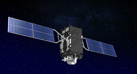
High-Precision Positioning with “Michibiki”
“Michibiki” (meaning “guidance”) is a Quasi-Zenith Satellite System (QZSS) that will make high-precision positional information services possible. Michibiki is expected to be utilized across a wide range of fields from autonomous vehicles and agricultural equipment to disaster prevention.
Today, the American-made global positioning system (GPS) is widely used to acquire positional information for car navigation, smartphones and so on. GPS makes use of approximately thirty satellites orbiting the earth. To supplement and reinforce GPS and achieve positioning with greater precision, Japan launched one satellite in 2010 and three more in 2017. Starting in 2018, this group of four satellites will begin operating as the Michibiki QZSS to provide high-precision positioning services. By having one satellite remain in geostationary orbit above the equator and the other three satellites revolve around the earth at a slight inclination from the equator, the satellites pass almost directly over Japan in a quasi-zenith orbit for approximately eight hours a day, per satellite.
“Since the three satellites pass directly over Japan for eight hours at a time in order, we will be able to receive radio waves from satellites positioned almost directly above Japan 24 hours a day,” explains Go Takizawa, executive director for QZSS Strategy at the Cabinet Office. The key point is the positions of the satellites “almost directly above” Japan. In other words, there will be satellites in a quasi-zenith orbit above Japan.
At least four satellites are needed to estimate the user position (latitude, longitude and height) and time. Since in practical conditions signals from satellites can be blocked by mountains and buildings, especially in valleys and urban areas, and because signals from satellites at low elevation angles are inappropriate for precise positioning, more satellites are needed to estimate the user position and time.
After the Michibiki service commencement, there will be one satellite in a quasi-zenith position above Japan for 24 hours a day, 365 days a year. Accordingly, the Michibiki system will contribute to precise user positioning in real time.
Positioning errors are caused by multiple factors. In addition to terrestrial factors such as mountains and buildings, the ionosphere, an electrically charged (ionized) layer that covers the earth, also plays a part. When signals from a satellite pass through the ionosphere they slow down, delaying the arrival of radio waves on earth. As this delay portion is calculated and the calculated delay is longer than the actual delay, an error develops. Michibiki has two features designed to avoid this issue and improve positioning accuracy. The first is the Sub-meter Level Augmentation Service, or SLAS. SLAS is based on a network of monitoring stations set up in thirteen locations around Japan to monitor the positions of the satellites. The monitoring stations will transmit supplementary signals to the satellites to correct for the positioning errors being received from Michibiki, which will reduce terrestrial positioning errors to within one meter. The second is the Centimeter Level Augmentation Service, or CLAS. CLAS will utilize accurate positioning data from approximately 1,300 Global Navigation Satellite System (GNSS)-based control stations set across Japan by the Geospatial Information Authority for the purposes of positioning and map creation to transmit error-corrected information to the satellites and reduce positioning errors to several centimeters (6 cm horizontally and 12 cm vertically, to 95% precision).
“Michibiki will enter operation with the four-satellite structure from next fiscal year. Using a dedicated receiver, it will be possible to access a high-precision positioning information service with a positioning error of a few centimeters, which is a world-first,” says Takizawa. “What’s more, the radio waves from Michibiki can also be utilized outside Japan by receivers across the Asia and Oceania regions.”
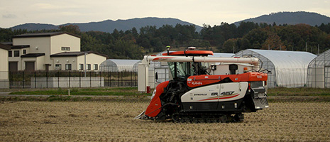
Various demonstration tests are currently underway ahead of Michibiki entering service. Tests on autonomously controlled agricultural machinery using radio signals from the Michibiki system were conducted on a tractor in Hokkaido in October 2017, and on a combine harvester in Kyoto in November. In both tests, the machinery succeeded in following a pre-determined route to a high level of accuracy. If the work of tractors and combine harvesters that require accurate control for longer time use can be automated, it could help with the labor shortages faced by farms run by an aging population. Other private sector-led initiatives using centimeter-level positioning services are also advancing, including autonomous driving tests on expressways in Hyogo Prefecture, and operational support for snowplows in Hokkaido.
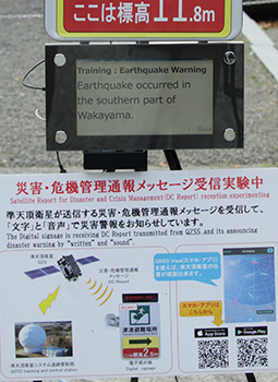
Meanwhile, in November 2017 during disaster evacuation drills conducted by Wakayama and Kochi prefectures, demonstration testing was conducted on the QZSS Safety Confirmation Service (Q-ANPI) that uses Michibiki’s message transmission feature, and the Satellite Report for Disaster and Crisis Management (DC Report) that provides electronic bulletin board and audio notification of disaster and crisis information such as tsunami alerts. Q-ANPI is a service that will take information from transceivers installed at evacuation centers and transmit information on evacuation center position, status and evacuees via Michibiki. DC Report, meanwhile, is a service that will transmit disaster information from government agencies via Michibiki to car navigation systems, as well as speakers and digital signboards connected to receivers installed outdoors. During the Great East Japan Earthquake that struck in 2011, terrestrial communications equipment was damaged by the ensuing tsunami, cutting off the means to send and receive information. If Michibiki is in place, that eventuality can be avoided.
“A wide range of uses for Michibiki including sports and tourism is also being envisioned,” notes Takizawa. “We hope the system is used by many people and businesses as a piece of infrastructure to create new markets. In that sense, I think there is the potential for new services that no one has even thought of before.”
There are plans to expand Michibiki to seven satellites in 2023. This would make it possible to receive signals from four Michibiki satellites at all times, allowing Michibiki to operate as a standalone positioning system.
With Japan’s unique centimeter-level high-precision positioning service, the satellite positioning system is about to make a further leap.


No article or any part there of may be reproduced without the express permission of the Cabinet Office. Copyright inquiries should be made through this form.
© 2009 Cabinet Office, Government of Japan