Home > Highlighting JAPAN > Highlighting Japan March 2018 > Technologies for Disaster Mitigation
Highlighting JAPAN
The Deepening of Disaster Science
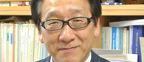
In April 2012, a little over a year after the Great East Japan Earthquake of March 2011, Tohoku University founded the International Research Institute of Disaster Science (IRIDeS) on its Aobayama campus in Sendai City, Miyagi Prefecture. We asked IRIDeS Director Fumihiko Imamura, a world-leading researcher in tsunami engineering, about the activities of the Institute.
Please tell us about the background and aims for establishing the IRIDeS
The Great East Japan Earthquake and accompanying tsunami of 2011 was a wide-range, complex disaster that greatly exceeded the various knowledge and technologies relating to natural disasters that we had fostered until that point and not enough advance measures were in place. As a university in the area affected, we established the IRIDeS with the mission to learn from this, minimize disaster damage and never repeat unexpected damage. A major objective of the Institute is the deepening of disaster science and the creation of action-oriented disaster management.
The deepening of disaster science is about framing the process chain of advance disaster measures, disaster occurrence, damage spreading, emergency measures, restoration and reconstruction, and preparations for the future as a disaster cycle as well as elucidating the challenges for each process and thinking about how to solve them.
By contrast, the creation of action-oriented disaster management is about customizing the results of disaster science research with an eye to regional features and culture, creating an academic discipline that can provide support in response to the disaster cycle in each region.
What research fields does the IRIDeS work in?
The IRIDeS consists of thirty-six fields in seven divisions, such as the Hazard and Risk Evaluation Research Division, the Regional and Urban Reconstruction Research Division, and the Human and Social Response Research Division. Our research covers a broad range of fields, from natural science including earthquakes, tsunami, and volcanoes to history, law, culture, education and other social sciences. An especially big feature is that we cover the fields of disaster medicine and medical science, including disaster-related infectious disease, public health, psychiatry, and so on. Furthermore, we are facilitating research on wide-area, complex disasters by collaborating across the boundaries of the natural, human and social sciences.
Since the founding of the IRIDeS, similar interdisciplinary research institutes have been established in Europe and North America, but we are the only institute in the world to gather as many as sixty-five full-time faculty members specializing in disasters.
Please tell us about your results so far.
The damage caused by the tsunami after the Great East Japan Earthquake was very different from other events in the past. Damage became more serious not only due to the bigger scale of the tsunami, but because of a combination of factors, such as the flow of the tsunami drawback, the behavior of drifting objects including cars, boats, buildings, topographical change and the concomitant expansion of inundation areas, and conflagrations. The IRIDeS used RIKEN’s K computer to develop a program for recreating and analyzing such damage. This will contribute greatly to tsunami countermeasures, such as hazard mapi formulation, in Japan and abroad.
Moreover, we created the Pocket Notebook for Family’s Disaster Resilience (Minna-no-Bosai Techo) in 2013 on the basis of research results and lessons learned from a variety of natural disasters such as the Great East Japan Earthquake. The notebook includes preparations and responses for each stage from disaster occurrence to restoration as well as contact methods for families. It was distributed to about 400,000 households mainly in the Tohoku region.
How is the IRIDeS’s international collaboration and cooperation?
For example, in order to communicate our lessons from the Great East Japan Earthquake, we are engaged in the Michinoku-Shinrokuden project, where we are working together with Harvard University in the United States to archive all our records. Moreover, we exchange graduate and undergraduate students with the University of Hawaii to foster human resources for disaster risk reduction. Furthermore, we are planning joint research and symposia in the field of disaster science with Monterrey Institute of Technology and Higher Education in Mexico, which suffered damage from a sequence of earthquakes in September 2017.
During the Third UN World Conference on Disaster Risk Reduction held in Sendai in 2015, the Sendai Framework for Disaster Risk Reduction, international guidelines for disaster risk reduction until 2030, was adopted. Building on this, the World Bosai Forum/International Disaster Risk Conference was held in Sendai for the first time in November 2017, gathering more than 900 participants representing national governments, local authorities, universities, civil society, businesses and international organizations in more than forty countries and regions. This forum centered on Asia and the Pacific Rim and became a venue for sharing insights about the Great East Japan Earthquake and lively discussions about the Sendai Framework for Disaster Risk Reduction. Continuing and developing this from here on is of utmost importance.
Please tell us about the next World Bosai Forum, which is planned for November 2019.
Through this next forum, we are hoping to spread the comprehensive concept of “Bosai” to the world for use at all stages from disaster risk reduction to restoration and reconstruction, thus contributing to disaster risk reduction around the world.
In this sense, continued engagement with restoration work following the Great East Japan Earthquake is also important. For example, we want to create networks of people and objects that can transmit lessons from the disaster to future generations. This can be done by training people who can present accounts of the disaster orally or by maintaining remains. We want to share this experience of wanting to transform the negative heritage of disaster into assets with the rest of the world.
Note
i A hazard map identifies areas susceptible to natural disasters such as tsunamis, earthquakes, volcanoes, storms and floods.


No article or any part there of may be reproduced without the express permission of the Cabinet Office. Copyright inquiries should be made through this form.
© 2009 Cabinet Office, Government of Japan