
INDEX
- English
- 日本語
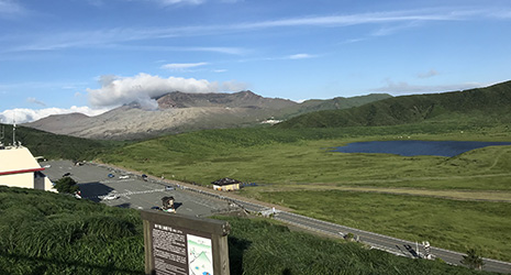
Mt. Nakadake viewed over Kusasenri-ga hama - English
- 日本語
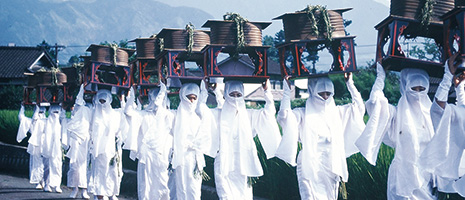
Scene from the Onda Matsuri
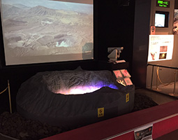
Live video stream of Mt. Nakadake’s crater
December 2020
Nature and Culture among the Aso Volcanoes
Aso Geopark in Kumamoto Prefecture is a place to learn about and appreciate not just the abundant nature formed by volcanic activity, but also the ways of life fostered by those who have coexisted with the volcanoes over the generations.
Aso Caldera is an enormous volcanic depression located roughly in the center of the island of Kyushu. The caldera as it appears today was formed by repeated extremely large eruptions between 270,000 and 9,000 years ago. Aso Caldera is oval shaped, measuring 18 kilometers from east to west and 25 kilometers from north to south, and is surrounded by an outer rim with a circumference of more than 100 kilometers. Aso Gogaku, the five peaks that comprise Mt. Aso, including Mt. Nakadake with its endless volcanic smoke, rise up from the center of the caldera, and a wide range of treasured animals and plants inhabit the surrounding grasslands and marshes that spread out from here.
Within the caldera, there are many springs, waterfalls and hot springs, and Aso has gained great popularity as a scenic area to enjoy various outdoor activities.
The Aso area was designated as a national park by the Japanese government in 1934, and the region has also been certified as a UNESCO Global Geopark. There are thirty-three geosites or places of interest with recognized value as natural heritage in Aso Geopark, the overarching theme of which is “human life and the natural environment around the Aso Volcano.” Here you can learn not only about the topography and geology created by volcanic activity, but also about the lifestyles, history and culture of the people who have a deep connection with this land.
Aso Volcano Museum, which overlooks the Kusasenri-ga-hama crater prairie and Mt. Nakadake in the distance, has welcomed more than 8 million visitors since its founding in 1982. As a hub for the Aso Geopark, the museum has been recognized as a base for the promotion of cultural tourism by the Agency for Cultural Affairs, Government of Japan. The museum investigates the local animals and plants, as well as the connection between the grasslands and the people since the formation of the Aso caldera. The museum collects and exhibits its materials, and offers educational programs for elementary, middle and high school students as well as hiking tours.
One of the museum’s special exhibits is the live video stream from cameras installed in Mt. Nakadake’s crater wall. The video, projected onto a 1/300 scale model of the Mt. Nakadake crater and accompanied by sounds from the crater, gives the viewer the sensation of looking into the volcano.
Museum director Ikebe Shin’ichiro says, “Our role is to convey the natural charm of Aso through the history of volcanic activity up until now. We guide visitors to respond to their intellectual curiosity; for example, when they ask why the mountain came to be the shape it is. Aso is a cool area of high altitude where volcanic ash has accumulated and as such is an environment unfit for cultivation. However, the soil has been improved with cow manure and green manure made from grass. In this way, we are trying to deepen the understanding of the unique culture of the people of Aso who have coexisted with the volcano for a long time.”
Pasturing has been passed down in Aso, which is the location of the most expansive grasslands in Japan. It is said that the pasturing of Aso cattle and horses goes back to the Nara and Heian periods (eighth to late twelfth centuries). People pasture cattle and horses from spring until autumn, and in autumn, the grasses are reaped. This reaped grass is used not only as food for the livestock, but also as green manure to grow rice and vegetables. In early spring, controlled burning is conducted in the grasslands to prevent shrubs and trees from taking over the land and to encourage the growth of new sprouts of grass. This work has been repeated every year for countless centuries, and agriculture and livestock industries have developed as the grasslands have been maintained.
Aso Shrine, home of the Deity of the Volcano Geosite and said to have been founded about 2,300 years ago, venerates the deity of the volcano that has been worshipped by people of the area for generations. Unique festivals are held at the shrine to coincide with the agricultural work of each season, such as the Onda Matsuri wishing for a good harvest during rice planting season and the Tanomisai giving thanks to the deities of Aso during the harvest. These festivals have been designated as Important Intangible Folk Cultural Properties of Japan.
As a hub for tourism in Kumamoto Prefecture, Aso Volcano Museum has also put effort into collecting and exhibiting materials related to Mt. Nakadake’s eruptions and the 2016 Kumamoto Earthquake. The museum is also involved in awareness programs for disaster prevention.
In addition to the Kumamoto Earthquake, Kumamoto Prefecture has experienced torrential rains and other disasters in recent years. Recovery has steadily progressed. The JR Hohi Line, which connects Kumamoto Prefecture with neighboring Oita Prefecture via Aso, was fully restored in August 2020 for the first time in more than four years. In October of 2020, a bypass for the important Japan National Route 57 was also completed, and Aso suddenly became more accessible. A new bridge is expected to open in March 2021 to replace the Aso Ohashi Bridge that collapsed under a quake-triggered landslide in 2016.
Travel by car, train or bicycle in Aso will be further improved in the future, and it will surely become possible to experience the charm of Aso Geopark even more, including the dynamic environment created by volcanoes and the culture that developed along with it.