
March 2023
- PREVIOUS
- NEXT
Support for Land Subsidence Countermeasures in Jakarta
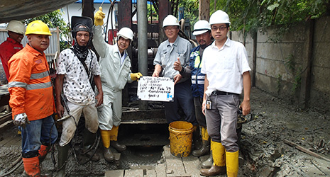
Tsuchiya Nobuyuki (third from left) at the construction site of a monitoring well in northern Jakarta 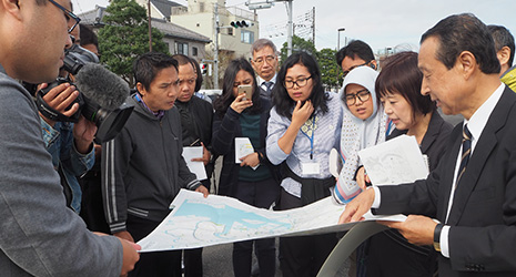
Participants from Indonesia learning about Tokyo’s land subsidence countermeasures during training held in Tokyo
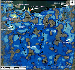
Distribution and magnitude of land subsidence areas in Jakarta from 2007 to 2020. The black area at the top is the sea. The areas highlighted in red and yellow experienced the greatest subsidence, which is measured in total mm. Data is from Japan’s ALOS (Advanced Land Observing Satellite) image analysis. 
Monitoring wells installed in northern Jakarta to observe the state of land subsidence
JICA is utilizing its experience in Tokyo to support countermeasures against land subsidence in Jakarta, the capital of the Republic of Indonesia.
Since the Meiji period (1868–1912), the modernization of Tokyo has progressed and there has been an increase in the population and the number of factories. As a result, the abstraction (removing) of groundwater for industrial use quickly increased and then land subsidence began. Since the 1950s, groundwater abstraction further increased along with an increase in population and economic growth. Subsidence proceeded all at once, with some areas sinking more than 4 meters. In the 1960s, the Japanese government and Tokyo Metropolitan Government established laws and regulations strictly regulating groundwater abstraction, and progress was made in securing alternate water sources through dam building and other means. As a result, subsidence has significantly slowed today.
Making use of this experience in Tokyo, the Japan International Cooperation Agency (JICA) implemented a project from 2018 to 2022 supporting land subsidence countermeasures in Jakarta, the capital of the Republic of Indonesia. In Jakarta, excessive groundwater abstraction by factories and commercial facilities has led to subsidence, especially in the northern parts of the city, where land has sunk up to 4 meters since the 1970s. As a result, some areas are experiencing seawater inundation at high tide. It is estimated that if land subsidence progresses more, risks of flooding, storm surges, and logistical stagnation due to these natural disasters will increase over a large area.
To implement the project effectively, JICA introduced the Integrated Water Resources Management concept. This concept refers to the systematic and comprehensive management of water use using fair methods and without damaging the sustainability of ecosystems in order to maximize the benefits gained from water.
“The central ministries and local governments involved in land subsidence are quite diverse. Without the cooperation of these related organizations, countermeasures cannot proceed,” says JICA Senior Advisor Nagata Kenji. “For that reason, we set up a Joint Coordinating Committee (JCC) for the project to gather all relevant parties together to engage in information sharing and discussions on countermeasures.”
One important initiative of the project was the collection of data. Before the project began, there wasn’t any clear evidence that groundwater abstraction was the cause of land subsidence. Regardless of the area, it was also not clearly understood just how much the land had sunk. To that end, first, the state of land subsidence from 2007 to 2020 was analyzed with data gathered from JAXA (Japan Aerospace Exploration Agency)’s Advanced Land Observing Satellite ALOS and its successor ALOS-2, both of which can measure changes in the ground using special radar. JICA also installed monitoring wells in three locations in northern Jakarta to observe the state of land subsidence above ground.
After analyzing data from the satellites, it became clear that the land in Jakarta from 2007 to 2020 sank from between around 2 centimeters to 102 centimeters. From the additional analysis of monitoring well records, it was confirmed that the land was sinking 10 to 15 millimeters per year. Additionally, it was discovered that the progress of subsidence had slowed in areas where groundwater abstraction had been reduced, and the causal association of groundwater abstraction and land subsidence became clear.
“Based on scientific data, we were able to show concerned parties where and to what degree land subsidence was occurring, as well as where it was occurring underground,” says Nagata. “This made it easy to establish land subsidence countermeasures.”
Effort was also made to convey experience in land subsidence countermeasures from Tokyo to relevant parties in Indonesia. As part of this effort, workshops were held in Indonesia and Japan for officials of central ministries and local governments in Indonesia. During training held in Japan, participants learned about techniques and the history of land subsidence countermeasures by the Japanese government and local governments through lectures. Participants also inspected monitoring wells and seawalls that act as countermeasures against storm surges and flooding.
“Tokyo succeeded in stopping land subsidence. However, ground that sank cannot be restored to what it once was. This is why even today we must continue countermeasures that are extremely costly, such as the construction of seawalls,” says Tsuchiya Nobuyuki, Technology Deputy Director at the Japan River Front Research Center. “I think that relevant parties in Indonesia deepened their understanding of land subsidence countermeasures by learning these lessons from Tokyo.”
After the project ended in November 2022, a Land Subsidence Planning and Implementation Committee (PIC) was set up as the successor to the JCC with the goal of implementing action plans. The action plans established by the JCC incorporate countermeasures such as the construction of additional monitoring wells, expansion of areas where well pumping is prohibited, the construction of seawalls, and expansion of land subsidence countermeasures for other cities.
“At the end of the project, when I met a high-ranking government official overseeing land subsidence countermeasures, he stressed to me that he would stop land subsidence in Jakarta by ensuring alternative water sources and through groundwater abstraction regulations,” says Tsuchiya. “Hearing this, I felt that the land subsidence countermeasures in Jakarta would make great progress. I think our project produced immense results.”
JICA is also carrying out investigations in and considering countermeasures for Ho Chi Minh City in the Socialist Republic of Vietnam where land subsidence is advancing. The lessons gained from Japan’s land subsidence will surely become even more important in the future for developing countries experiencing significant economic growth.
- PREVIOUS
- NEXT