March 2022
Forecasting Tsunami Damage in Real Time
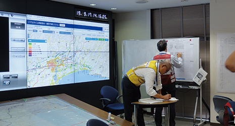
Disaster response training using the real-time tsunami inundation and damage forecasting system at the Kochi Prefectural Office -
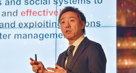
Professor Koshimura Shunichi, CTO (Chief Technical Officer) of RTi-cast
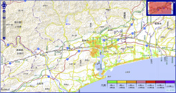
Image of reports estimating tsunami damage of buildings 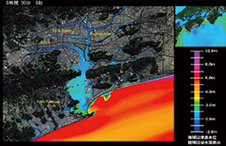
Image of a tsunami inundation forecast at the test site, Kochi Prefecture
To support social resilience against a tsunami disaster, a Japanese venture company has developed the world’s first system to quickly and accurately forecast tsunami damage immediately after an earthquake occurs.
Responding to damage from tsunamis is a pressing matter for many countries and regions that face the sea, including Japan. It is still fresh in the minds of the Japanese people that nearly 20,000 people lost their lives or went missing from a large tsunami after the Great East Japan Earthquake that occurred in March 2011.
In April 2018, the world’s first system to forecast tsunami inundation and estimate damage in real time began full operations to support early recovery from tsunami damage. The company that developed the system is RTi-cast, a disaster science venture company that got its start at Tohoku University. The company was founded in March 2018 as an industry-academia collaborative venture together with Kokusai Kogyo Co., Ltd., a leading company in the disaster prevention environment industry, NEC, A2 Corp., and other private companies working on earthquake early warning receivers.
Koshimura Shunichi, CTO (Chief Technical Officer) of RTi-cast, describes conventional tsunami prediction systems as “database models” and the tsunami prediction system developed by RTi-cast as a “real-time forward model.”
“For the conventional database model, the Japan Meteorological Agency finds the scale and location of an earthquake when it occurs, checks this information against a pre-calculated tsunami forecast database, and looks for the height of the tsunami estimated along the coast. Our real-time forward model, however, is based on information on an earthquake that has just occurred, forecasting the scale of the tsunami, how it is propagating towards the coast, how it will penetrate inland, and the status of damage that occurs following the tsunami inundation, all in real time. Compared to the conventional database model, this model is considerably more accurate because the forecasts are made taking into account the latest topographic and coastal facility information, and the use of supercomputers makes it possible to make a forecast in a short amount of time.”
Specifically, the system first estimates the fault rupture mechanism within 10 minutes of the earthquake, and within the following 10 minutes computes tsunami inundation areas and the maximum inundation depth for every 10 meter area. Combined with buildings, roads, and other spatial information, the system then estimates damage to buildings. It only takes 20 minutes since an earthquake occurred to complete inundation forecast and building damage estimates.
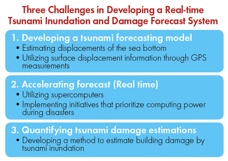
According to Professor Koshimura, there were three technological challenges in developing and implementing the real-time tsunami inundation and damage forecast system.
The first challenge was in estimating mechanisms of fault* rupture in real time.
“We have to think about sea bottom deformation due to fault ruptures to estimate the initial sea surface displacement. To do so, we acquire crustal movement observation data from the approximately 1,300 observation points around Japan operated by the Geospatial Information Authority of Japan (GSI) and earthquake early warning information (earthquake location, depth, and magnitude) from the Japan Meteorological Agency and make an estimate of the fault model from these data.”
The second challenge was in accelerating tsunami simulation to offer tsunami forecasts in real time.
“Use of supercomputers with high performance computing infrastructures is essential in simulating tsunamis in real time. However, supercomputers are in operation in a variety of other research areas, and they cannot always be used. So we developed a novel operation and algorithm that automatically prioritizes the code of tsunami forecasting whenever an earthquake occurs.”
The third challenge was in establishing a quantitative method of building damage estimation.
“We can quantitatively understand the damage by visualizing it on a map, estimating how much damage will occur on buildings and how many people will be affected in certain areas. For example, the empirical relationship between tsunami inundation depth and building damage implies two meters of flow depth would cause severe damage or total destruction. For this, we use damage data from the Great East Japan Earthquake.”
This system is currently in operation as one of the functions of the Disaster Information System in the Cabinet Office, Government of Japan, which oversees disaster prevention in the government.
“The system currently distributes a forecast report regarding tsunami height along the coast, the inundation zone and the maximum inundation depth, the number of buildings to be washed away, population information within the inundation zone, and more, within 30 minutes of a large-scale earthquake occurring. This report is intended for use as materials in the first meeting at the Disaster Management Headquarters of Japan immediately following a large-scale earthquake tsunami. Without the damage forecast information, it was not possible to immediately understand the areas that would be damaged or the scale of the affected areas of the Great East Japan Earthquake. If we can estimate the damage in a quantitative manner in real time, it can lead to quicker and more effective recovery in the affected areas as we can quickly determine where medical response activities are needed and how much other support is needed.”
Regarding the future of this system, Professor Koshimura says, “We are currently operating the system for the Pacific and Japan Sea coasts, from the main islands of Kyushu to Hokkaido, and this will be expanded to all of Japan. In the future, I hope to grow the system into one that is aimed at regular people and can convey tsunami dangers wherever a person is in real time.”
* Gaps of underground bedrock caused by forces applied to it from its surroundings. Earthquakes are formed and ground shaking occurs when there is sudden fault movement as these gaps move.